A floodway home sits in the most restricted channel area, while a floodplain home sits in the broader area exposed to the base flood. Because the base flood has a 1% annual chance of occurring in any given year and a home in the 100-year floodplain carries a 26% chance of flooding during a 30-year mortgage, either property can create settlement problems beyond ordinary property division.
You may be trying to sell a Kingwood house, refinance it, or decide whether one spouse can afford to keep it after divorce. Then a question that seemed administrative becomes central: Is the property in the floodway, in the broader floodplain, or outside the mapped hazard area because elevation documentation changes the analysis? That answer can affect equity, insurance, repairs, financing, and the realism of every proposed settlement.
A flood-prone residence isn't just another line on a Texas divorce inventory. A house near the San Jacinto River, a bayou, or a drainage corridor may carry restrictions and expenses that don't appear in a standard appraisal. Families in Humble, Porter, and Northeast Houston can face the same issue, particularly when a map designation and the home's physical elevation tell different stories.
Dividing a Flood-Prone Marital Residence in Kingwood
A Kingwood couple may begin divorce negotiations with a familiar plan. One spouse keeps the house and pays the other spouse an offset from retirement funds, or the couple lists the home and divides the net proceeds. That plan becomes harder when the home has flooded before, sits near a mapped conveyance channel, or requires insurance and repairs that the proposed owner can't comfortably carry.
The emotional pressure is real. One spouse may remember water entering the home during Hurricane Harvey, while the other focuses on the appraised value and assumes the next buyer or lender will accept the same numbers. A disagreement over flood risk can quickly become a disagreement over credibility, disclosure, and who should bear an uncertain future expense.
Practical rule: Don't negotiate the residence as though its location were merely a neighborhood detail. Confirm the map designation, the elevation evidence, the insurance history, and the repair obligations before treating a proposed buyout as final.
Kingwood's history gives these disputes a concrete local context. During Hurricane Harvey in 2017, roughly 5,000 Kingwood homes flooded, while broader Lake Houston-area reporting cited about 16,000 flooded homes and 3,300 flooded businesses. Historical Houston-area coverage also described flooding in 1994, when 90 subdivisions and about 3,400 homes flooded, and local reporting attributed extensive Kingwood flooding during Harvey to water flowing down the San Jacinto River and pooling as it entered Lake Houston. These figures and explanations appear in local reporting on Kingwood flood preparation and flood history.
Why the legal inventory needs more detail
Texas property division is not a simple mathematical split. The court divides the community estate in a manner it considers just and right, and the practical value of an asset includes the obligations attached to it. A residence with restricted rebuilding options, expensive coverage, or unresolved flood damage may not provide the same usable benefit as a similar-looking home elsewhere.
The issue can arise in discovery, mediation, temporary orders, or trial. A spouse may need to establish the home's condition, previous claims, current policy requirements, and likely compliance work. The other spouse may challenge a proposed discount or argue that the property remains valuable because buyers still purchase homes in Kingwood.
Local counsel can help organize those competing positions around documents instead of assumptions. A divorce lawyer serving Kingwood can also coordinate the property issue with related questions about temporary possession, support, debt allocation, and the timing of a sale. Families should also understand the court process through the Harris County Family Courts: A Kingwood Resident's Guide, which describes how family law cases proceed in the Harris County courts serving Kingwood.
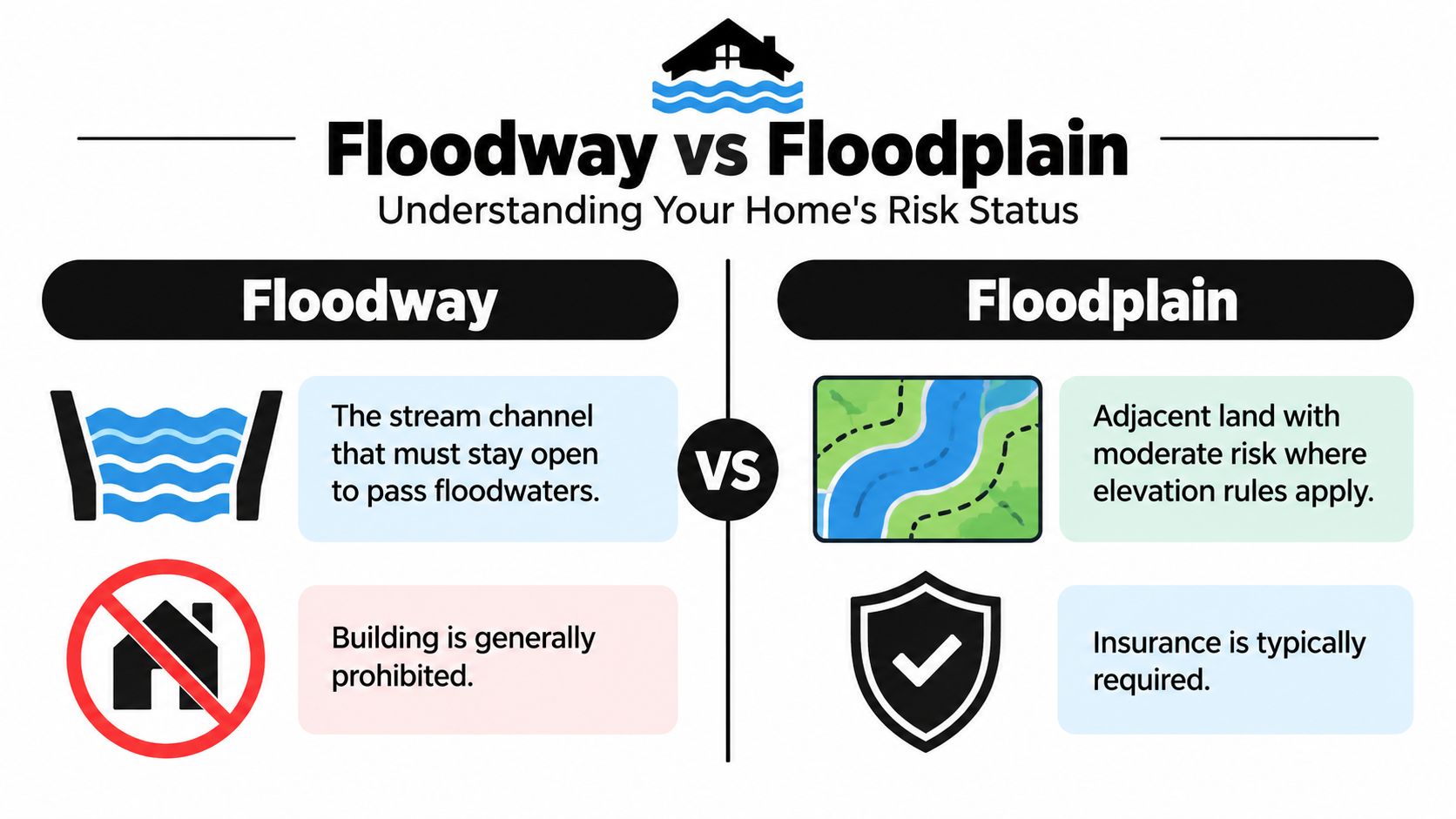
Floodway vs Floodplain Understanding Your Home's Risk Status
The distinction is functional, not cosmetic. FEMA defines the floodway as the stream channel plus adjacent land that must remain open to pass the base flood. The floodplain is the broader area covered by those floodwaters, and the floodway and flood fringe together form the base floodplain or special flood hazard area. That makes a floodway the most tightly regulated part of the broader hazard area. FEMA's guide to calculating flood loads explains the base-flood framework used for these distinctions.
| Question | Floodway | Broader floodplain |
|---|---|---|
| What is it? | The channel and adjacent land needed to convey the base flood | Land susceptible to inundation beyond the primary conveyance area |
| Why does it matter? | It carries the highest flow and generally creates the tightest development constraints | It can still trigger elevation, insurance, repair, and reconstruction requirements |
| Divorce impact | May limit improvement, rebuilding, financing, and buyout assumptions | May reduce marketability and increase carrying costs even where the home isn't in the floodway |
| Local example | Property beside a mapped river or bayou conveyance channel | Property in nearby low-lying land that falls within the broader mapped flood hazard |
A home in Kingwood or Humble can be near a stream, bayou, or drainage corridor without being inside the floodway. That doesn't make the home risk-free. It means the appraiser and attorney must identify whether the property faces the special constraints of the conveyance area or the different, though still material, risks of the surrounding floodplain.
Read the map with the property documents
Texas floodplain mapping data can include 3-meter resolution and layers for the 1% and 0.2% flood frequencies, among other screening information, as described by the Texas Water Development Board floodplain dataset. A street address alone may not answer the question precisely enough for a divorce settlement. Review the parcel, structure location, survey, elevation information, and applicable local rules together.
A floodway designation is a structural and land-use issue, not just an insurance label. Houston permitting materials describe the floodway as the primary conveyance area for storm runoff along a watercourse and explain that it is mapped on FEMA Flood Insurance Rate Maps. The floodplain frequently asked questions also illustrates the practical distinction between land susceptible to inundation and the channel area needed to convey floodwater.
An accurate map review can change the settlement conversation. A house outside the floodway may still be difficult to insure or improve, but a house inside the floodway may face a substantially different assumption about lawful rebuilding and resale. Those facts should be addressed before a spouse promises to refinance or pay an offset.
How Flood Status Affects Property Valuation and Equity
A market appraisal is a starting point, not always the final answer. Floodplain status can affect what buyers will pay, what insurers will charge, and what a lender will accept as a stable basis for financing. In a divorce, the relevant question is often the home's net equity, meaning the value available after debt, selling expenses, insurance obligations, necessary repairs, and other property-specific costs.
Peer-reviewed nationwide housing-market evidence found that floodplain designation reduced sale values by about 2.1% on average, with modeled full pricing effects ranging from 4.7% to 10.6%. The same study noted that nonfloodplain homes often qualify for Preferred Risk Policies costing about $300 to $500 per year, while comparable floodplain coverage can cost roughly double. Those figures come from the peer-reviewed analysis of floodplain designation and housing values.
The figures shouldn't be applied mechanically to every Kingwood property. A particular house may have unusual elevation, prior repairs, desirable improvements, a favorable certificate, or a location that buyers view differently from the national sample. But the evidence supports a practical conclusion: flood status belongs in the valuation analysis rather than being ignored because a nearby comparable sold for more.
Separate market value from usable value
Consider a residence with a conventional mortgage and a proposed spouse-to-spouse buyout. The parties may start with the appraised value, subtract the mortgage, and divide the remainder. That calculation can overstate what the retaining spouse receives if the property requires specialized coverage, has unresolved compliance work, or will be difficult to sell later.
A more useful worksheet should identify:
- Current market value: Obtain an appraisal that discloses the floodway or floodplain location and considers comparable properties with similar exposure.
- Debt and transaction costs: Account for the mortgage, likely sale expenses, and any liens or repair-related obligations.
- Insurance burden: Obtain current declarations, renewal information, deductibles, exclusions, and any required coverage.
- Physical and regulatory exposure: Identify repairs, elevation work, utility protection, rebuilding restrictions, and permit issues.
- Future marketability: Ask whether a buyer, lender, or insurer may view the property differently because of its designation.
A floodway location can justify a further risk analysis beyond ordinary floodplain pricing because the highest-velocity and deepest-water portions of the hazard area create greater physical exposure and tighter development assumptions. That doesn't automatically produce a particular discount. It does require an appraiser and the lawyers to explain why a generic neighborhood comparison may not reflect the property's actual financial position. A focused discussion of this issue appears in San Jacinto River floodplain home appraisal in a divorce.
Insurance, Elevation Certificates, and Mitigation Costs
The spouse who keeps a flood-prone home also keeps its carrying costs. Those costs may include flood insurance, deductibles, elevation work, protected utilities, repairs required for lawful improvement, and documentation needed to correct or clarify the property's mapped status.
Verify the elevation before assigning the risk
Start with the current FEMA map and local floodplain information. Then gather the survey, prior elevation certificate, building permits, insurance declarations, claim records, and records of flood repairs. If the building site is higher than the Base Flood Elevation, a licensed land surveyor or registered professional engineer can prepare an Elevation Certificate.
The certificate doesn't change the map by itself. An owner can submit the professional documentation with a FEMA Letter of Map Amendment, or LOMA, to request formal verification that the property or building is above the Base Flood Elevation. Texas guidance describes this process in floodplain management materials concerning Elevation Certificates and LOMAs.
That paperwork can matter during refinancing, sale, and property division. A spouse shouldn't claim that the home is effectively outside the risk area based only on personal observation, and the other spouse shouldn't assume the mapped designation automatically answers every elevation question. The formal certificate and map-correction process provide a more reliable record.
Calculate the cost of keeping the house
Texas guidance requires utilities, appliances, and equipment to be raised above the Base Flood Elevation or otherwise protected when floodplain standards apply. A home that appears affordable based on its mortgage payment may become less affordable when the retaining spouse must fund compliant repairs or protect critical systems. The Texas Quick Guide to floodplain management describes these elevation and protection requirements.
Build the carrying-cost analysis from actual records rather than guesses:
- Request the current flood policy, renewal documents, deductible, and payment history.
- Identify whether the lender requires coverage and whether the policy covers the risks the spouse expects it to cover.
- Ask a qualified professional which utilities, appliances, or equipment need elevation or protection.
- Confirm whether past work was permitted and whether future work will require floodplain approval.
- Put responsibility for premiums, deductibles, repairs, certificates, and future mitigation directly into the decree or settlement agreement.
A flood insurance policy or claim payment can also create a separate property question depending on its source and use. The parties should address that issue specifically rather than treating every insurance payment as ordinary home equity, as discussed in flood insurance proceeds and community or separate property in Texas.
Strategies for Dividing a Flood-Zone Home
There isn't one correct disposition for every flood-prone residence. The right option depends on the property's actual status, the available cash or credit, the condition of the structure, and whether either spouse can accept the long-term risk without relying on an optimistic resale assumption.
Sale to a third party
A sale can create the cleanest separation when the parties can't agree on risk or when neither spouse can comfortably fund insurance and compliance costs. Before listing, disclose known flood history and obtain accurate map and elevation information. A buyer who discovers a floodway issue after the contract may challenge the transaction, request concessions, or terminate under the contract terms.
A sale also requires realistic pricing. Overpricing a floodway home because a standard appraisal looks favorable can leave the parties paying mortgage, insurance, and maintenance expenses while the property sits on the market. Underpricing it without professional support can give one spouse an avoidable argument that the other accepted less than fair value.
Buyout by one spouse
A buyout may work when the retaining spouse has dependable income, access to funds, and a lender willing to refinance the property after accounting for its flood status. The settlement should use an insurance-adjusted equity calculation and identify who pays future premiums, deductibles, repairs, elevation work, and any required certificates.
A floodway designation can make a conventional buyout less realistic because development and rebuilding assumptions are more restrictive. Even if a spouse wants to stay in the Kingwood home, the parties should confirm that refinancing and lawful improvement are practical before assigning a value to the proposed offset.
Deferred sale or transfer
A deferred sale can protect children's housing stability or allow the parties time to resolve repairs, insurance, or marketability concerns. It can also prolong financial ties and create new disputes if the decree doesn't specify possession, maintenance, taxes, insurance, flood claims, repairs, access for inspections, and the exact event that triggers listing.
A transfer subject to future review should include a clear deadline or objective condition. A vague promise to sell when the market improves doesn't answer who bears a premium increase, what happens after another flood, or how the parties will resolve disagreement over list price. Local families can review the legal and financial issues surrounding a possible buyout or public flood-control acquisition through information about a Harris County flood control buyout and a divorce decree.
Settlement guidance: Choose the option that remains workable after a difficult insurance renewal, a required repair, or a realistic inspection. A plan that works only if nothing changes is not a durable property division.
Common Mistakes in Flood-Prone Property Settlements
The first mistake is treating the appraised market value as the home's complete economic value. A conventional appraisal may not answer whether the structure can be rebuilt in its current form, whether a lender will refinance it, or whether the retaining spouse can afford the insurance and mitigation obligations.
The second is confusing floodplain status with floodway status. Both deserve analysis, but they don't impose the same structural assumptions. A floodway can restrict the use of the land and make improvements or rebuilding more difficult, while a home elsewhere in the floodplain may have more workable options subject to elevation and local permitting rules.
What settlement documents should address
- Insurance: State who obtains and pays for flood coverage, homeowners coverage, deductibles, renewals, and claim-related expenses.
- Compliance: Assign responsibility for Elevation Certificates, LOMAs, permits, protected utilities, and required elevation work.
- Damage: Explain who controls a claim, receives insurance proceeds, selects contractors, and pays any gap between coverage and repair cost.
- Sale terms: Set the listing process, appraisal procedure, price review, broker selection, and response to a buyer's flood-related inspection.
- Access and maintenance: Cover inspections, repairs, landscaping, drainage work, and access when one spouse remains in possession.
Texas floodplain planning guidance states that new or substantially improved homes must be built up above the Base Flood Elevation, and some local ordinances require 2 feet of additional freeboard. It also gives the example that certain residential construction rules require a LOMA or LOMR to remove construction from a Special Flood Hazard Area and require the lowest floor of adjacent residential construction to be at least 2 feet above the Base Flood Elevation. These requirements are described in Texas floodplain planning guidance.
Don't leave future obligations outside the decree because the parties hope to cooperate. A spouse assigned the home may later face a premium change, a repair mandate, or a failed refinancing attempt. The spouse receiving other assets may discover that the offset was based on equity the retaining spouse cannot realize. A precise agreement reduces that risk.
Recent draft FEMA map activity also shows why map status shouldn't be treated as permanently settled. Reporting on draft FEMA flood maps for Harris County and Houston describes ongoing changes that may affect how Houston-area properties are categorized. The legal effect of a map update depends on the applicable process and effective date, but parties negotiating today should identify which map and supporting documents their valuation uses.
Next Steps for Kingwood Homeowners
Before negotiating the residence, identify the facts that will control its value and future use. Compare the FEMA map version used by any appraisal with current Harris County mapping, the floodway or floodplain designation, and any pending map update. A changed boundary can affect marketability, financing, insurance, and the assumptions behind an equity offset.
Test each proposed settlement against the spouse's actual options. For a buyout, confirm that refinancing is available after accounting for insurance and required repairs. For a deferred sale, state who pays taxes, insurance, maintenance, flood damage, and mitigation costs, and set deadlines for listing or sale. For a transfer of other assets, document whether the home's stated equity is based on a realistic sale value or an assumption that cannot be realized.
Bring your current FEMA map printout, your elevation certificate, and your last three flood insurance declarations to your consultation. Those three documents let us calculate net equity in under ten minutes rather than leaving it as an open question. Add the mortgage payoff statement, recent repair invoices, and any lender or insurer correspondence if those issues are disputed.
A Kingwood divorce attorney can then compare a sale, buyout, or deferred-sale arrangement under Texas property-division principles. The Law Office of Bryan Fagan, Kingwood TX Lawyers, also handles custody, support, estate planning and probate, criminal defense, and civil disputes, but the flood-prone residence requires its own documented valuation analysis.
Schedule a free consultation at the Kingwood office with those records in hand. Visit Law Office of Bryan Fagan, Kingwood TX Lawyers to discuss the floodway or floodplain residence and the settlement structure.